

ZIMBABWE ON THE MAP
The landlocked country of Zimbabwe lies to the south of the equator and it borders Zambia to the north-west, Mozambique to the north-east, South Africa and Botswana to the south. It covers 390,757 km², of which 3910 km² are covered by water. The Zambezi River is the northern border of Zimbabwe.
The landscape can be divided into three geographical regions: the inland plateau, the Highveld and the Escarpment. The 1,200 m high inland plateau takes up the majority of the country. The peneplains extend between the cities of Harare and Bulawayo. The landscape sinks to the west into the Kalahari basin. The plateau falls away in the north and south towards the Lowveld.
Zimbabwe has several major tourist attractions. Victoria Falls on the Zambezi, which are shared with Zambia, are located in the north west of Zimbabwe. The Victoria Falls National Park is also in this area and is one of the eight main national parks in Zimbabwe, the largest of which is Hwange National Park.
The Eastern Highlands are a series of mountainous areas near the border with Mozambique. The highest peak in Zimbabwe, Mount Nyangani at 2,593 m (8,507 ft) is located here as well as the Bvumba Mountains and the Nyanga National Park. World’s View is in these mountains and it is from here that places as far away as 60–70 km (37–43 mi) are visible and, on clear days, the town of Rusape can be seen.
Zimbabwe is unusual in Africa in that there are a number of ancient and medieval ruined cities built in a unique dry stone style. Among the most famous of these are the Great Zimbabwe ruins in Masvingo. Other ruins include Khami Ruins, Zimbabwe, Dhlo-Dhlo and Naletale.
The Matobo Hills are an area of granite kopjes and wooded valleys commencing some 35 km (22 mi) south of Bulawayo in southern Zimbabwe. The hills were formed over 2,000 million years ago with granite being forced to the surface, then being eroded to produce smooth “whaleback dwalas” and broken kopjes, strewn with boulders and interspersed with thickets of vegetation. Mzilikazi, founder of the Ndebele nation, gave the area its name, meaning ‘Bald Heads’. They have become a tourist attraction due to their ancient shapes and local wildlife.
Visas
If you are not staying for longer than six months, you enter Zimbabwe with a minimum of formalities. All you need is a valid passport with a valid visa depending on which category of the visa regime you fall under, a return ticket to your country (or enough money to buy one), and sufficient funds to cover your stay in Zimbabwe.
Money
The mostly acceptable means of payment in most establishments is US $ based or its equivalent. Travelers Cheques and International credit cards are widely accepted. Avoid street/border money changers. Instead it is advisable to change all your money or travelers cheques at Commercial banks, hotels or registered bureau de change.
Security
Zimbabweans are known for their hospitality and friendliness towards each other and visitors alike. Although all Zimbabweans are very helpful it is always advisable to be cautious when dealing with strangers. Police officers are very helpful and are easily identified by their uniforms. Like everywhere in the world valuables should always be safeguarded or left in the hotel safe box. If you do not know where to obtain a certain service or you are not sure always contact the Zimbabwe Tourism Authority, Police Post or the hotel information desk.
Zimbabwe’s official name is Republic of Zimbabwe. Southern Rhodesia, the Republic of Rhodesia, and Zimbabwe Rhodesia were all previous names for the country. Cecil John Rhodes, whose firm administered the area during the late 19th and early 20th centuries, was the inspiration for Zimbabwe’s previous name, Rhodesia.
The name Zimbabwe is derived from the Shona phrase “Dzimba dza mabwe,” which means “huge stone dwellings.” The name is derived from the stone structures of Great Zimbabwe, also known as Dzimbahwe, which were designated as a UNESCO World Heritage Site in 1986.
English is the main language used in the education and judicial systems. The Bantu languages Shona and Ndebele are the principal indigenous languages of Zimbabwe. Shona is spoken by 78% of the population, Ndebele by 20%. Other minority Bantu languages include Venda, Tsonga, Shangaan, Kalanga, Sotho, Ndau and Nambya.
Zimbabwe, lying north of the Tropic of Capricorn, is completely within the tropics but enjoys subtropical conditions because of its high average elevation. Toward the end of the hot, dry months, which last from August to October, monsoon winds that have crossed the Indian Ocean and Mozambique result in intense orographic rainfall when they meet the rampart formed by the eastern highlands. The eastern regions consequently receive the country’s heaviest rainfall and have a more prolonged rainy season (lasting from October into April) than the rest of Zimbabwe. The high altitude of the broad plateau of western Zimbabwe helps to guarantee fine weather there during the cool, dry winter months from May to August.
June is generally the coolest month and October the warmest; temperature variations correspond closely to altitude. Inyanga, at about 5,500 feet in the eastern highlands, varies in temperature from a mean of 52° F (11° C) in July to one of 65° F (18° C) in October. Harare, at about 4,800 feet, has seasonal temperatures varying from 57° F (14° C) to 70° F (21° C), and Bulawayo, at 4,400 feet, varies from 57° F (14° C) to 70° F (21° C). Daily variations about these means are some 13° F (7° C) warmer in the afternoon and 13° F (7° C) cooler at night. Harare and Bulawayo each average about eight hours of sunshine per day, and this average does not drop below six hours during the rainy season.
Victoria Falls – Africa’s most spectacular waterfall.
Zambezi National Park – A popular day trip from Victoria Falls. Elephant and buffalo are plentiful.
Hwange National Park – known for huge elephant herds.
Mana Pools National Park – is highly recommended for walking safaris and canoeing are the focus.
Great Zimbabwe – a ruined city that formerly served as the capital and now houses the ruins of one of Africa’s most prominent civilizations
Lake Kariba – for boating and fishing
Matobo National Park – for its dramatic rock landscape
Top Attractions
Discover the natural wonders of Zimbabwe!
-

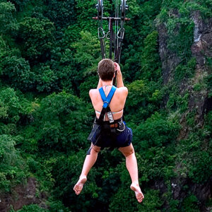
Adrenaline High Wire – (Flying Fox, Zip Line & Gorge Swing)
$165.00Defy gravity and soar with the birds! Monkey Trails offers you the opportunity to sail through the air and gaze down upon the Zambezi River and its ancient gorges.
Select date(s) -

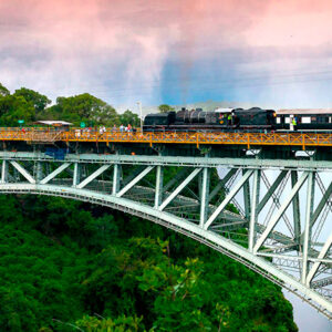
Bridge Tour
$68.00The Historic Victoria Falls Bridge Tour takes visitors on a journey through a century of Victorian engineering to the core of Cecil John Rhodes’ concept for a Cape to Cairo railway.
Select date(s) -

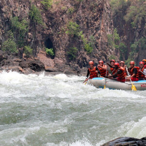
Rafting – Five Days, Four Nights – ZIM
$1,246.00Arguably the wildest white water in the world, rafting on the Zambezi River is an adrenaline rush not to be missed. The rapids on the Zambezi River are officially defined as “Grade 5” by the British Canoe Union (Grade 6 being commercially un-runnable). Clients should be reasonably fit for this activity, as there is a steep walk into & out of the Batoka Gorge as well as the white water rafting activity itself.
Select date(s)


