Weather forecast in Makgadikgadi-Nxai NP

Things to Know

The Makgadikgadi Pans is the world’s largest salt pan landscape.
Imagine can area the size of Portugal, largely uninhabited by humans. Its stark, flat, featureless terrain stretches meeting and fusing with a milky-blue horizon. This is the Makgadikgadi – an area of 12 000 sq kms, part of the Kalahari Basin, yet unique to it – one of the largest salt pans in the world.
For much of the year, most of this desolate area remains waterless and extremely arid; and large mammals are thus absent. But during and following years of good rain, the two largest pans – Sowa to the east and Ntwetwe to the west – flood, attracting wildlife – zebra and wildebeest on the grassy plains – and most spectacularly
flamingos at Sowa and Nata Sanctuary. Flamingo numbers can run into the tens – and sometimes – hundreds of thousands, and the spectacle can be completely overwhelming.
The rainwater that pours down on the pans is supplemented by seasonal river flows – the Nata, Tutume, Semowane and Mosetse Rivers in the east, and in years of exceptional rains, the Okavango via the Boteti River in the west.
During this time, the pans can be transformed into a powder blue lake, the waters gently lapping the shorelines, and flowing over the pebble beaches – a clear indication of the gigantic, prehistoric lake the Makgadikgadi once was. Research suggests that the Makgadikgadi is a relic of what was once one of the biggest inland lakes Africa has ever had.
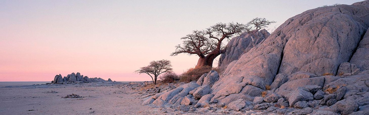
Africa’s most famous explorer, Dr. David Livingstone, crossed these pans in the 19th century, guided by a massive baobab, Chapman’s Tree – believed to be 3 000 to 4 000 years old, and the only landmark for hundreds of miles around. Seeing this amazing tree today, you are given entry to an era when much of the continent was uncharted, and explorers often risked their lives navigating the wilderness on oxcarts through rough and grueling terrain.
The Makgadikgadi is in fact a series of pans, the largest of which are Sowa and Ntwetwe, both of which are surrounded by a myriad of smaller pans. North of these two pans are Kudiakam pan, Nxai Pan and Kaucaca Pan. Interspersed between the pans are sand dunes, rocky islands and peninsulas, and desert terrain.
No vegetation can grow on the salty surface of the pans, but the fringes are covered with grasslands. Massive baobab trees populate some fringe areas – and their silhouettes create dramatic landscapes against a setting sun.
The Makgadikgadi Pans Game Reserve – with an area of 3 900 sq kms – incorporates the western end of Ntwetwe, extensive grasslands and acacia woodland. At its northern boundary, it meets the Nxai Pan National Park, separated only by the Nata- Maun Road.
In the wet season, this reserve can offer good wildlife viewing, particularly when large herds of zebra and wildebeest begin their westward migration to the Boteti region. other species include gemsbok, eland and red hartebeest, as well as kudu, bushbuck, duiker, giraffe, springbok, steenbok, and even elephant, with all the accompanying predators, as well as the rare brown hyena.
Humans have inhabited areas of the pans since the Stone age, and have adapted to geographical and climatic changes as they have occurred. Archaeological sites on the pans are rich with Early Man’s tools, and the bones of the fish and animals he ate.
Human inhabitation has continued to the present day; and a number of villages, including Mopipi, Mmatshumo, Nata, Gweta and Rakops, are situated on the fringes of the pans. Nxai Pan National Park
Part of the great Makgadikgadi complex, Nxai Pan National Park covers an area of 2 100 sq kms, and comprises several larger pans – Nxai Pan, Kgama-Kgama Pan and Kudiakam Pan, which were once ancient salt lakes. These larger pans are now grassed, and are scattered with islands of acacia trees, and smaller pans that fill with water during the rainy season – thus providing rich resources for wildlife.
Wildlife viewing is seasonal, and dependent on if and when the rains come, and when animals migrate. There are several artificial watering points. If the rains have been good, December to April is the best time to visit.
Common species to be sighted are zebra, wildebeest, springbok, impala, gemsbok, hartebeest, giraffe, lion, cheetah, wild dog, brown hyena, bateared fox, and sometimes elephant and buffalo.
The park is one of the more accessible areas of the Makgadikgadi, a mere 50 kms from the Nata-Maun Road.
Baines' Baobabs
Approximately 30 kms from the Nxai Pan National Park entrance, Baines’ Baobabs are a highlight for any visitor travelling this area of Botswana.
Seven huge, gnarled baobab trees, named after the 19th century explorerThomas Baines, are situated on a promontory or island overlooking and surrounded by the white, crusty Kudiakam Pan. Baines stood here over a hundred years ago and painted this otherworldly scene. It has essentially remained unchanged.
Thomas Baines was an explorer, artist, naturalist and cartographer. He and fellow explorer James Chapman travelled through this area during their two-year journey from Namibia to Victoria Falls (1861-63).
They travelled in horse-drawn wagons and on foot, accompanied and led at different times by Hottentots, damaras (a tribe from Namibia) and San. They encountered numerous difficulties, including the harshness of the desert, thirst, hunger, illness, and more than once, desertion by their guides, who made off with their supplies.
Despite all this, Baines’ account of the journey is filled with appreciation of the beauty of africa. ‘I confess,’ he wrote, ‘I can never quite get over the feeling that the wonderful products of nature are objects to be admired rather than destroyed; and this, I am afraid, sometimes keeps me looking at a buck when i ought to be minding my hindsights.’
Baines’ painting of the small island of baobabs shows covered wagons, people tending their horses, and a huge baobab bursting with leaves. ‘We walked forward to the big tree, the Mowana at Mamu ka Hoorie, and found the country much improved,’ Baines wrote of the gloriously shaded area.
Baines’ diaries, sketches, drawings and paintings provide fascinating first-hand documentation of that most Africa. Decisive era in the history of Southern Africa.

The Zebra and Wildebeest herds migrate in their thousands to the river at the end of winter to access the water. The Makgadikgadi is a harsh, dry environment, suited to Oryx and Kudu, but the river provides a life-giving source of water for the Zebra and Wildebeest utilising the eastern grass plains.
After the start of the rainy season, this desert area teems with wildlife as herds of Zebra and Wildebeest graze to their hearts’ content on the wide-open green grassland plains of the Makgadikgadi. During the wet season there is an influx of migratory bird species, while resident desert species welcome their visitors by showing off their breeding plumage.
The longest mammal migration in the world
If you visit the pans in the dry season, when the landscape is arid and the land is as dry as a bone, you might not believe that it hosts Africa’s longest zebra migration. During the wet season (around January to March) the pans transform into lush, nutritious wetlands, which attract zebras, wildebeests, elephants and other herbivores. If you want to witness this spectacle, the Makgadikgadi Pans are the best place to be.
A study that focused on the zebra migration had eight adult female Burchell’s zebras (Equus quagga) tracked via GPS collars. According to the results, the herd crossed the Chobe River on Botswana’s border with Namibia, and moved south to Nxai Pan, at the onset of rains in the Pans area. This multi-country migration of zebras is the longest of all recorded large mammal migrations in Africa. The study was conducted by WWF and Namibia’s Ministry of Environment and Tourism, in collaboration with Elephants without Borders and Botswana’s Department of Wildlife and National Parks.
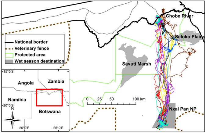
As the migrating zebra would not have known routes followed by previous generations before the fences were erected (and subsequently removed), it has now been suggested that zebras instinctively have the ancient migratory routes conserved in their memory. This could be genetically encoded, which explains how these black and white striped herbivores follow the same route corridors decades later.
A completely different migration, the Okavango-Makgadikgadi zebra migration – that involves 15,000 zebras – was witnessed by researchers during 2008–2009 for the first time after the removal of a veterinary fence which was blocking an already existing route. This event also suggests that it might be a genetically encoded phenomenon.
This 500 km return journey from the Chobe River to Nxai Pan and back is longer than the well-known Serengeti/Maasai Mara migration. And some of the zebras traveled far greater distances, if they diverted to other food sources en-route, before resuming the journey to Nxai Pan. The migration timing depends on rainfall during the rainy season of January to April. On one occasion (2012), researchers noticed that the zebras only embarked on their journey in December, several days after significant rainfall in the Nxai Pan area.
The migration occurs in the protected land of the Kavango-Zambezi Transfrontier Conservation Area (KAZA) – the largest transboundary conservation area in the world. It stretches across five southern Africa countries – Angola, Botswana, Namibia, Zambia and Zimbabwe, covering 440,000 square kilometres. This also shows how important it is for wildlife to preserve the raw wilderness of certain areas and to allow animals to move freely across the borders.
The Makgadikgadi Pans’ climate is hot and desert-like. As with the rest of the country, the park experiences a distinct Dry and Wet season. In the Dry season, temperatures tumble at night, making it advisable to bring warm clothing for early morning game drives.
Dry season – April to October
The last of the rains typically fall in April. The park begins to look parched as the Dry season progresses. June and July represent the most pleasant daytime temperatures, but the mercury starts rising in August, and peaks in October and November.
April & May – The beginning of the Dry season is mostly dry, sunny and enjoyable. The middle of the day has an average temperature of about 29°C/84°F. June, July & August – It is cooler during the heart of the Dry season, with temperatures rising to around 26°C/79°F in the afternoon. Rainfall is very limited. Be prepared for chilly conditions in the early morning (temperatures are about 7°C/45°F).
September & October – Conditions at night, and in the morning, are agreeable at the end of the Dry season. However, the days get sweltering before the rains finally break. By October, temperatures of 34°C/93°F make the park extremely hot.
Wet season – November to March
There is great relief when the first rains fall. It immediately cools down a bit, and it’s less dusty. It seldom rains the whole day – afternoon thunderstorms and short showers are commonplace. It continues to be very warm throughout the season, with temperatures of about 32°C/90°F in the afternoon.
November & December – The end of the year is hot and frequently sunny and only rains sporadically. Early mornings have average temperatures of around 19°C/65°F, making them very comfortable.
January & February – These months receive the most rainfall. It can rain in the afternoon, but generally not for too long. This time of year is associated with heavy storms.
March – This month sees a decrease in rainfall, but it can still rain every couple of days, and thunderstorms are still around. Mornings have pleasant conditions with temperatures of about 17°C/63°F.
Getting There
The easiest way to get to the Makgadikgadi Pans’ is t either Maun Airport (MUB) or Kasane Airport (BBK). Other nearby airports include Victoria Falls Airport (VFA) in Zimbabwe; and Harry Mwanga Nkumbula International Airport (LVI) in Zambia and Mpacha Katima Mulilo Airport in Namibia. Makgadikgadi is located 162km/100mi east of Maun. The park can be reached on a self-drive safari, an organized mobile safari, or a fly-in safari.
This region can also be accessed via aircraft charter flights from surrounding airports. The Pans are found between the cities of Francistown in the east and Maun in the west, with smaller towns of Sowa, Nata and Gweta located around the upper section. An excellent stopover for visitors driving from Gaborone to northern Botswana is the Khama Rhino Sanctuary near historic Serowe which is just off the main highway en-route to Francistown.
What to do
Some lodges offer activities year-round, but this is a general overview
Anytime - Meerkat interaction, star gazing, cultural visits
Dry Season - guided walks with Bushmen, quad-biking on the pans, excursions
Wet Season - day and night game drives, nature walks, bird watching, scenic flights
Prepare for the hot climate
It is warm in the day-time even in winter (although there is a huge drop in temperature at night in peak winter months). October is the hottest month. Most safari activities occur in the morning or evening when it is cooler to avoid the intense midday heat.
